

Empowering People with Geospatial
the easiest way to share, visualize and work
with geospatial data online

Ingest
Upload orthophoto, terrain, pointcloud, vector data, mesh models, and more
Work with and share them in a 3D web browser environment. Add more data through our marketplace where you’ll find both free and licenced external data sources.

Visualize
Visualize your data through our unique plugin system.
Add and edit annotations, shapes and measurements. View 3D models to locate and search your images. Add bookmarks with actions and scripting to colorize, add movement and scaling, camera manipulations, all through an easy plug-and-play system.

Customize
Customizable UI through a role-based system.
From administrators to users to public shared links. Set up user rules for how they can visualize, share, download and otherwise work with your geospatial data.
Your Teams
Users, Access Privileges, Controls,
Sharing, Delivery, Collaboration, Internal & External.
Your Data
Satellite, Aerial, Drone, Terrestrial,
Imagery, DTMs, Pointcloud, Mesh models, Photos, GIS
Public and Commercial data repositories
How You Want It
Customise your working environment to suit your needs. Plugin architecture to quickly support custom apps and visualization.

Customization
Need something slightly different? We’re a research and development company with a fantastic team of people, doing both software and hardware design and development. We can extend 4DMapper easily through our unique plugin architecture, or create whole applications suited to your needs.
Our technology is designed to run on multiple different stacks and operating systems, in the cloud, in most server stacks, or in local off-line environments. At the center of everything we do you’ll find a secure and dynamic RESTful API that either we or you can use and modify for all your geospatial needs and integrations.
Get your free 4DMapper account today
Instant access to existing sample data and projects
Where do you want Your 4DMapper?
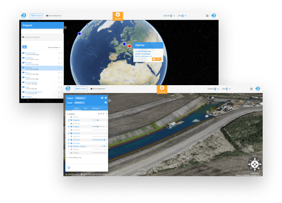
4DMapper Online
4DMapper is your live, secure, collaborative, web-based environment with automated tiling engines to stream any open data formats including 3D terrain, mesh, ortho, point-cloud, GIS, raster and vector data.
Data fusion, layering and monitoring over time. Collaborate, share, deliver securely in 3D, analyze, inspect and measure.
Powerful “model to photo” digital asset inspection, auditing and reporting tools and connectivity to your external databases. Advanced terrain analytics, comparisons and volumetrics, 3D digitizing, feature extraction and exporting.
All this with a full set of controls to manage users, teams and clients with controlled sharing and delivery.
4DMapper on Your Cloud Server
Like what you see in the cloud?
4DMapper can also be installed on your own AWS or Azure servers, as well as on a stand-alone integrated computer (CAN), to be fully customized
with support for a number of databases, security integrations, third-party format streaming, and much more.
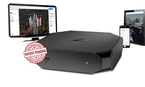
4DMapper CAN
The Contained Area Network (4DMapper CAN), our patent-pending solution, brings all of the power of the 4DMapper Cloud to a portable server, online or offline. Bring full control to projects on your local area network or as your own private cloud on remote worksites.
No internet connections and data upload bottlenecks.
4DMapper CAN transforms from a single private-cloud field device, to a wide area server with full control over data, clients, accessibility, storage and applications.
